5.4.3.12 IfcSite
A site is a defined area of land, possibly covered with water, on which the
project construction is to be completed. A site may be used to erect, retrofit
or turn down building(s), or for other construction related developments.
NOTE Term according to ISO6707-1 vocabulary
"area of land or water where construction work or other development is
undertaken".
A site may include a definition of the single geographic reference point for
this site (global position using WGS84 with Longitude,
Latitude and Elevation). The precision is provided up to
millionth of a second and it provides an absolute placement in relation to the
real world as used in exchange with geospational information systems. If
asserted, the Longitude, Latitude and Elevation
establish the point in WGS84 where the point 0.,0.,0. of the
LocalPlacement of IfcSite is situated.
The geometrical placement of the site, defined by the
IfcLocalPlacement, shall be always relative to the spatial structure
element, in which this site is included, or absolute, i.e. to the world
coordinate system, as established by the geometric representation context of
the project. The world coordinate system, established at the
IfcProject.RepresentationContexts, may include a definition of the
true north within the XY plane of the world coordinate system, if provided, it
can be obtained at IfcGeometricRepresentationContext.TrueNorth.
A project may span over several connected or disconnected sites. Therefore
site complex provides for a collection of sites included in a project. A site
can also be decomposed in parts, where each part defines a site section. This
is defined by the composition type attribute of the supertype
IfcSpatialStructureElements which is interpreted as follow:
- COMPLEX = site complex
- ELEMENT = site
- PARTIAL = site section
The IfcSite is used to build the spatial structure of a
building (that serves as the primary project breakdown and is
required to be hierarchical).
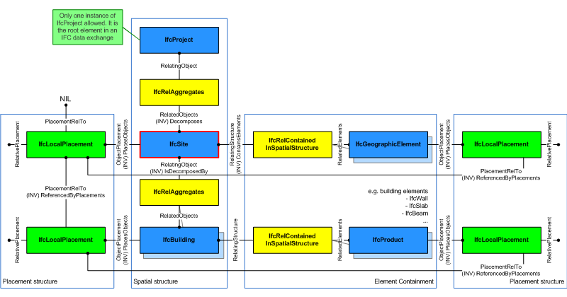
Figure 32 shows the IfcSite as part of the spatial structure. In addition to the logical spatial structure, also the placement hierarchy is shown. In this example the spatial structure hierarchy and the placement hierarchy are identical.
NOTE Detailed requirements on mandatory element containment and placement structure relationships are given in view definitions and implementer agreements.
|
Figure 32 — Site composition
|
HISTORY New entity in IFC1.0.
Attribute Use Definition
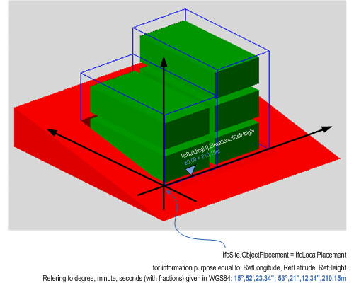
Figure 33 describes the heights and elevations of the IfcSite. It
is used to provide the geographic longitude, latitude, and height above sea
level for the origin of the site. The origin of the site is the local
placement.
The provision of longitude, latitude, height at the IfcSite for
georeferencing is provided for upward compatibility reasons. It requires a
single instance of IfcSite and WGS84 as coordinate reference
system.
For exact georeferencing (or referencing to any other geographic coordinate
system other than WSG84) the entities IfcCoordinateReferenceSystem and
IfcMapConversion have to be used to define an exact mapping of the
project engineering coordinate system to the geographic (or map) coordinate
system.
- reference height of site is provided by:
IfcSite.RefElevation, it is given according to the height datum used
at this location.
- the reference height of each building situated at the site is given
againt the same height datum used at this location.
- the elevations of each storey belonging to each building are given
as local height relative to the reference height of the building.
 |
|
Figure 33 — Site elevations
|
Construction Operations
A site is a defined area of land, possibly covered with water, on which the project construction is to be completed. A site may be used to erect building(s) or other AEC products.
 Instance diagram
Identity
The Identity concept applies to this entity.
| Exchange |
|
|
|
|
|
|
|
|
|
|
|
|
|
|
|
|
|
|
|
|
|
|
|
|
|
|
|
|
| Import |
R |
R |
R |
R |
R |
R |
R |
R |
R |
R |
R |
R |
R |
R |
R |
R |
R |
R |
R |
R |
R |
R |
R |
R |
R |
R |
R |
R |
| Export |
R |
R |
R |
R |
R |
R |
R |
R |
R |
R |
R |
R |
R |
R |
R |
R |
R |
R |
R |
R |
R |
R |
R |
R |
R |
R |
R |
R |
Spatial Composition
The Spatial Composition concept applies to this entity as shown in Table 29.
| Spatial Composite | Description |
|---|
| | A site is contained in a project, where COBie requires a project to contain a single site. |
|
Table 29 — IfcSite Spatial Composition |
| Exchange |
|
|
|
|
|
|
|
|
|
|
|
|
|
|
|
|
|
|
|
|
|
|
|
|
|
|
|
|
| Import |
R |
R |
R |
R |
R |
R |
R |
R |
R |
R |
R |
R |
R |
R |
R |
R |
R |
R |
R |
R |
R |
R |
R |
R |
R |
R |
R |
R |
| Export |
R |
R |
R |
R |
R |
R |
R |
R |
R |
R |
R |
R |
R |
R |
R |
R |
R |
R |
R |
R |
R |
R |
R |
R |
R |
R |
R |
R |
Revision Control
The Revision Control concept applies to this entity.
| Exchange |
|
|
|
|
|
|
|
|
|
|
|
|
|
|
|
|
|
|
|
|
|
|
|
|
|
|
|
|
| Import |
O |
O |
O |
O |
O |
O |
O |
O |
O |
O |
O |
O |
O |
O |
O |
O |
O |
O |
O |
O |
O |
O |
O |
O |
O |
O |
O |
O |
| Export |
O |
O |
O |
O |
O |
O |
O |
O |
O |
O |
O |
O |
O |
O |
O |
O |
O |
O |
O |
O |
O |
O |
O |
O |
O |
O |
O |
O |
XSD Specification:
<xs:element name="IfcSite" type="ifc:IfcSite" substitutionGroup="ifc:IfcSpatialStructureElement" nillable="true"/>
<xs:complexType name="IfcSite">
<xs:complexContent>
<xs:extension base="ifc:IfcSpatialStructureElement"/>
</xs:complexContent>
</xs:complexType>
EXPRESS Specification:
|
|
| RefLatitude | : | OPTIONAL IfcStrippedOptional; |
| RefLongitude | : | OPTIONAL IfcStrippedOptional; |
| RefElevation | : | OPTIONAL IfcStrippedOptional; |
| LandTitleNumber | : | OPTIONAL IfcStrippedOptional; |
| SiteAddress | : | OPTIONAL IfcStrippedOptional; |
|
Attribute Definitions:
| RefElevation | : | Datum elevation relative to sea level.
|
| LandTitleNumber | : | The land title number (designation of the site within a regional system). |
| SiteAddress | : | Address given to the site for postal purposes. |
Inheritance Graph:
|
|
| ObjectType | : | OPTIONAL IfcStrippedOptional; |
|
|
|
| ObjectPlacement | : | OPTIONAL IfcStrippedOptional; |
| Representation | : | OPTIONAL IfcStrippedOptional; |
|
|
|
| LongName | : | OPTIONAL IfcStrippedOptional; |
|
|
|
| CompositionType | : | OPTIONAL IfcStrippedOptional; |
|
|
|
| RefLatitude | : | OPTIONAL IfcStrippedOptional; |
| RefLongitude | : | OPTIONAL IfcStrippedOptional; |
| RefElevation | : | OPTIONAL IfcStrippedOptional; |
| LandTitleNumber | : | OPTIONAL IfcStrippedOptional; |
| SiteAddress | : | OPTIONAL IfcStrippedOptional; |
|
 Link to this page